
Abingdon topographic map
Interactive map
Click on the map to display elevation.
About this map
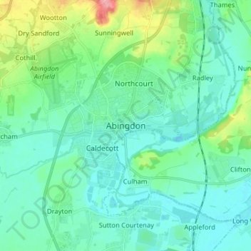
Name: Abingdon topographic map, elevation, terrain.
Average elevation: 64 m
Minimum elevation: 45 m
Maximum elevation: 136 m
Other topographic maps
Click on a map to view its topography, its elevation and its terrain.
Woolstone
United Kingdom > England > Oxfordshire > Vale of White Horse
Woolstone, Vale of White Horse, Oxfordshire, England, United Kingdom
Average elevation: 143 m
Uffington
United Kingdom > England > Oxfordshire > Vale of White Horse
Uffington, Vale of White Horse, Oxfordshire, England, United Kingdom
Average elevation: 138 m
Harwell
United Kingdom > England > Oxfordshire > Vale of White Horse
Harwell, Vale of White Horse, Oxfordshire, England, United Kingdom
Average elevation: 90 m
Milton Heights
United Kingdom > England > Oxfordshire > Vale of White Horse > Milton
Milton Heights, Milton, Vale of White Horse, Oxfordshire, England, OX14 4BG, United Kingdom
Average elevation: 72 m
Harrowdown Hill
United Kingdom > England > Oxfordshire > Vale of White Horse
Harrowdown Hill, Vale of White Horse, Oxfordshire, England, OX13 5ET, United Kingdom
Average elevation: 74 m
Lamborough Hill
United Kingdom > England > Oxfordshire > Vale of White Horse > Dry Sandford > Lamborough Hill
Lamborough Hill, Wootton, Dry Sandford, Vale of White Horse, Oxfordshire, England, OX13 6BY, United Kingdom
Average elevation: 92 m
Wantage
United Kingdom > England > Oxfordshire > Vale of White Horse > Wantage
Wantage, Vale of White Horse, Oxfordshire, South East England, England, United Kingdom
Average elevation: 151 m
Radley
United Kingdom > England > Oxfordshire > Vale of White Horse
Radley, Vale of White Horse, Oxfordshire, England, United Kingdom
Average elevation: 66 m
Watchfield
United Kingdom > England > Oxfordshire > Vale of White Horse
Watchfield, Vale of White Horse, Oxfordshire, England, United Kingdom
Average elevation: 97 m
Vale of White Horse
United Kingdom > England > Oxfordshire > Vale of White Horse
Vale of White Horse, Oxfordshire, South East England, England, United Kingdom
Average elevation: 105 m