
Thank you for supporting this site ❤️
Make a donation
Make a donation
Cerros topographic map
Click on the map to display elevation.
Thank you for supporting this site ❤️
Make a donation
Make a donation
About this map
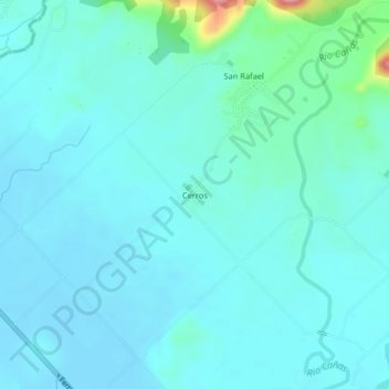
Name: Cerros topographic map, elevation, terrain.
Location: Cerros, Quepos, Puntarenas, 60601, Costa Rica (9.47840 -84.20489 9.51840 -84.16489)
Average elevation: 19 m
Minimum elevation: 2 m
Maximum elevation: 127 m
Thank you for supporting this site ❤️
Make a donation
Make a donation
Other topographic maps
Click on a map to view its topography, its elevation and its terrain.