
Thank you for supporting this site ❤️
Make a donation
Make a donation
Pike Road topographic map
Click on the map to display elevation.
Thank you for supporting this site ❤️
Make a donation
Make a donation
About this map
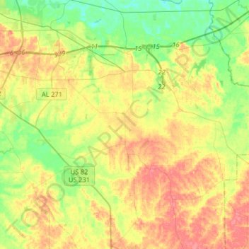
Name: Pike Road topographic map, elevation, terrain.
Location: Pike Road, Montgomery County, Alabama, 36064, United States (32.20707 -86.21740 32.39095 -85.95852)
Average elevation: 73 m
Minimum elevation: 45 m
Maximum elevation: 105 m
Thank you for supporting this site ❤️
Make a donation
Make a donation
Other topographic maps
Click on a map to view its topography, its elevation and its terrain.
Thank you for supporting this site ❤️
Make a donation
Make a donation
Thank you for supporting this site ❤️
Make a donation
Make a donation
Thank you for supporting this site ❤️
Make a donation
Make a donation