
Fansipan topographic map
Interactive map
Click on the map to display elevation.
About this map
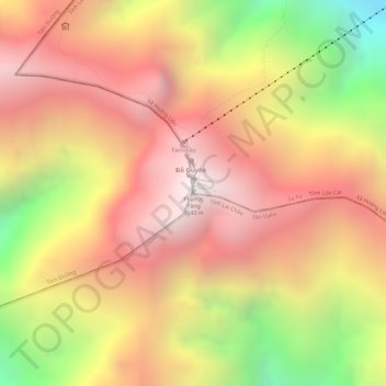
Name: Fansipan topographic map, elevation, terrain.
Location: Fansipan, Xã Hoàng Liên, Sa Pa, Provinz Lào Cai, Vietnam (22.30299 103.77546 22.30309 103.77556)
Average elevation: 2,616 m
Minimum elevation: 1,822 m
Maximum elevation: 3,099 m
Der Fansipan (vietnamesisch Phan Xi Păng bzw. Phan Si Păng) ist ein Berg im Hoàng-Liên-Sơn-Gebirge. Mit einer Höhe von 3143 m ist er sowohl der höchste Gipfel Vietnams wie auch Indochinas. Er wird daher auch als "Dachgiebel Indochinas" (vietn. Nóc nhà Đông Dương) bezeichnet.