
Make a donation
Iloilo City topographic map
Click on the map to display elevation.
Make a donation
About this map
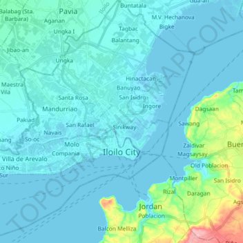
Name: Iloilo City topographic map, elevation, terrain.
Location: Iloilo City, Western Visayas, 5000, Philippines (10.63932 122.48797 10.78119 122.61716)
Average elevation: 17 m
Minimum elevation: -2 m
Maximum elevation: 156 m
Make a donation
Other topographic maps
Click on a map to view its topography, its elevation and its terrain.
Quezon City
Founded as a pueblo by Saint Pedro Bautista in 1590, San Francisco del Monte may be considered Quezon City's oldest district. The original land area of the old town of San Francisco del Monte was approximately2.5 square kilometres (1.0 sq mi) and covered parts of what is currently known as Project 7 and 8 and…
Average elevation: 57 m
Indang
Philippines > Cavite > Indang
The topography of Indang is characterised by gently sloping or rolling terrain. Almost 40.36% of its total land area is within the slope grade of 3-8%, while 2,135 hectares is within the slope range of 8-15% which is characterised by undulating or sloping terrain.
Average elevation: 298 m
Legazpi
Legazpi's topography is generally plain on the northeastern areas, with slopes ranging from five to fifteen degrees. The southern areas have mostly rolling to hilly terrain. In the city's coastal areas, the terrain varies from plain (north) to hilly (south). Legazpi is criss-crossed by several rivers including…
Average elevation: 150 m
Make a donation
Mount Banahaw
Philippines > Quezon > Tayabas
The andesitic Banahaw volcanic complex is composed of several stratovolcanoes with Mount Banahaw, the largest with a maximum elevation of 2,170 metres (7,119 ft) above mean sea level. The summit is topped by a 1.5 by 3.5 kilometres (0.93 mi × 2.17 mi) and 210 metres (690 ft) deep crater that is breached on…
Average elevation: 1,730 m
Make a donation
Bacolod
Bacólod (English: Bacolod), is derived from bakólod (Old Spelling: bacólod), the Old Hiligaynon (Old Ilonggo) (Old Spelling: Ylongo and Ilongo) word for a "hill, turtle, mound, rise, hillock, down, any small eminence or elevation", since the resettlement was founded on a stony, hilly area, now the barangay…
Average elevation: 49 m
Antipolo
Its higher elevation than that of Metro Manila affords it a scenic view of the metropolis, especially at night. Its locally grown mangoes and cashews are popular among tourists, as well as suman – a local delicacy made out of glutinous rice. The Hinulugang Taktak National Park, which was once a popular…
Average elevation: 125 m
Make a donation
Valencia
Philippines > Negros Oriental > Valencia
Valencia occupies an area of 14,749 hectares (36,450 acres), 35% of which are classified as plains. The town is 65% mountainous, with elevation averaging from 200 to 500 metres (660 to 1,640 ft) above sea level, with the top of Mount Talinis at an elevation of 1,903 metres (6,243 ft) along the municipal…
Average elevation: 250 m
Pinabacdao
For administrative and statistical convenience, barangays are group into two districts - the Pinabacdao East District and Pinabacdao West District. The East district is composed of barangays situated in high altitude areas or those located in the eastern part of the municipality. Barangays located along…
Average elevation: 11 m
Make a donation
Make a donation
Zamboanga City
Philippines > Zamboanga Peninsula > Zamboanga City
The overall topography of the city could be described as rolling to very steep. There are some flat lands, mostly narrow strips along the east coast. The urban center is mostly flat with a gentle slope to the interior, ranging from 0 to 3%. The highest registered elevation is 1,200 metres. In terms of slope, a…
Average elevation: 83 m
Make a donation
Make a donation
Make a donation
Tagaytay
The southern and eastern portions of Tagaytay are covered by hills and mountains which is generally forests, pine trees and open grasslands. The city lies along Tagaytay Ridge, a ridge stretching about 32 kilometres (20 mi) from Mount Batulao in the west to Mount Sungay in the east with elevations averaging…
Average elevation: 229 m
Make a donation
Make a donation
Make a donation
Make a donation
Trece Martires
The city of Trece Martires is characterised with ground elevation ranging from 30m to nearly 400m. Its ground slope ranges from 0.5 to 2%.
Average elevation: 150 m
Make a donation
Make a donation
Cabadbaran
Philippines > Agusan del Norte
It is 29 kilometres (18 mi) from Butuan. It is generally flat with rolling hills and swamplands in its western part. The highest of all mountains in the Caraga region, Mount Hilong-Hilong (with an altitude of 2,012 metres (6,601 ft) above sea level), rises in this city.
Average elevation: 179 m
Mandaluyong
Another claims that the Spaniards named the place based on the report of a navigator named Acapulco, who saw the rolling hills frequently being lashed at by daluyong (“big waves from the sea”). This seems to confirm traditional pre-Hispanic stories that giant waves from the sea would meet the adjoining…
Average elevation: 33 m
Make a donation
Baguio
In 1903, Filipinos, Japanese and Chinese workers were hired to build Kennon Road, the first road directly connecting Baguio with the lowlands of La Union and Pangasinan. Before this, the only road to Benguet was Naguilian Road, and it was largely a horse trail at higher elevations. Camp John Hay was…
Average elevation: 881 m
Make a donation
Make a donation
Make a donation
Make a donation
Make a donation
Make a donation
Make a donation
Make a donation
Make a donation
Make a donation