
Istanbul topographic map
Interactive map
Click on the map to display elevation.
About this map
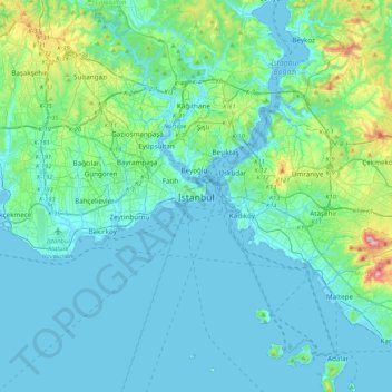
Name: Istanbul topographic map, elevation, terrain.
Location: Istanbul, Fatih, İstanbul, Marmararegion, 34122, Türkei (40.84638 28.81587 41.16638 29.13587)
Average elevation: 57 m
Minimum elevation: -2 m
Maximum elevation: 429 m
Geologen halten es für wahrscheinlich, dass sich bei Istanbul in naher Zukunft ein Beben mit einer Stärke von 7,0 oder höher ereignen wird.
Other topographic maps
Click on a map to view its topography, its elevation and its terrain.