
Woodbury County topographic map
Interactive map
Click on the map to display elevation.
About this map
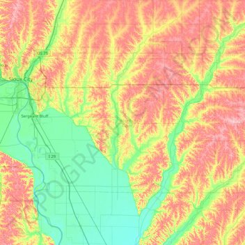
Name: Woodbury County topographic map, elevation, terrain.
Location: Woodbury County, Iowa, United States of America (42.21127 -96.49899 42.56223 -95.66915)
Average elevation: 376 m
Minimum elevation: 316 m
Maximum elevation: 460 m
Other topographic maps
Click on a map to view its topography, its elevation and its terrain.
Harpers Ferry
United States of America > Iowa > Harpers Ferry
Harpers Ferry, Allamakee County, Iowa, United States of America
Average elevation: 216 m
Keystone
United States of America > Iowa > Keystone
Keystone, Benton County, Iowa, 52249, United States of America
Average elevation: 272 m
Westgate
United States of America > Iowa > Westgate
Westgate, Iowa, United States of America
Average elevation: 333 m
Clarke County
United States of America > Iowa
Clarke County, Iowa, United States of America
Average elevation: 331 m
Van Buren County
United States of America > Iowa
Van Buren County, Iowa, United States of America
Average elevation: 217 m
Fraser
United States of America > Iowa > Fraser
Fraser, Boone County, Iowa, United States of America
Average elevation: 307 m
Story County
United States of America > Iowa
Story County, Iowa, United States of America
Average elevation: 308 m
Iowa County
United States of America > Iowa
Iowa County, Iowa, United States of America
Average elevation: 249 m
Evander
United States of America > Iowa > Evander
Evander, O'Brien County, Iowa, United States of America
Average elevation: 433 m
Iowa City
United States of America > Iowa > Iowa City
Iowa City, Johnson County, Iowa, United States of America
Average elevation: 216 m
Des Moines
United States of America > Iowa > Des Moines
Des Moines, Polk County, Iowa, United States of America
Average elevation: 264 m