
Đakrông topographic map
Interactive map
Click on the map to display elevation.
About this map
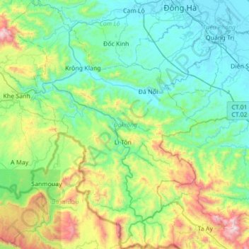
Name: Đakrông topographic map, elevation, terrain.
Location: Đakrông, Quảng Trị, Vietnam (16.30280 106.71099 16.83323 107.14070)
Average elevation: 373 m
Minimum elevation: -1 m
Maximum elevation: 1,730 m
Other topographic maps
Click on a map to view its topography, its elevation and its terrain.
Cao điểm đồi Rockpile
Cao điểm đồi Rockpile, Quốc lộ 9, Đakrông, Quảng Trị, Vietnam
Average elevation: 76 m