
Ubinas topographic map
Interactive map
Click on the map to display elevation.
About this map
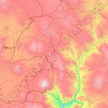
Name: Ubinas topographic map, elevation, terrain.
Location: Ubinas, General Sánchez Cerro, Moquegua, Perú (-16.44751 -70.98656 -15.97596 -70.65599)
Average elevation: 4,366 m
Minimum elevation: 2,559 m
Maximum elevation: 5,617 m
Other topographic maps
Click on a map to view its topography, its elevation and its terrain.
Lomas de Tacahuay
Lomas de Tacahuay, Ilo, Moquegua, Perú
Average elevation: 743 m
Las Lechuzas
Las Lechuzas, Moquegua, Mariscal Nieto, Moquegua, Perú
Average elevation: 1,331 m
Volcán Ubinas
Volcán Ubinas, Ubinas, General Sánchez Cerro, Moquegua, Perú
Average elevation: 5,174 m
Quellaveco
Quellaveco, Torata, Mariscal Nieto, Moquegua, Perú
Average elevation: 3,861 m
Quinistacas
Perú > Moquegua > Quinistacas
Quinistacas, Omate, Provincia de General Sánchez Cerro, Moquegua, Perú
Average elevation: 2,496 m