Geolocate

Kruin Park topographic map

Interactive map

Click on the map to display elevation.

About this map

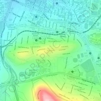
Name: Kruin Park topographic map, elevation, terrain.

Location: Kruin Park, Lukasrand, Tshwane Ward 59, Pretoria, City of Tshwane Metropolitan Municipality, Gauteng, South Africa (-25.76613 28.20603 -25.76382 28.21521)

Average elevation: 1,380 m

Minimum elevation: 1,322 m

Maximum elevation: 1,524 m

Other topographic maps

Click on a map to view its topography, its elevation and its terrain.

Apies

South Africa > Gauteng > City of Tshwane Metropolitan Municipality > Pretoria

Apies, Pretoria, City of Tshwane Metropolitan Municipality, Gauteng, South Africa

Average elevation: 1,250 m

Faerie Glen Nature Reserve

South Africa > Gauteng > City of Tshwane Metropolitan Municipality > Pretoria

Faerie Glen Nature Reserve, Tshwane Ward 46, Pretoria, City of Tshwane Metropolitan Municipality, Gauteng, South Africa

Average elevation: 1,385 m

Freedom Park

South Africa > Gauteng > City of Tshwane Metropolitan Municipality > Pretoria

Freedom Park, Tshwane Ward 59, Pretoria, City of Tshwane Metropolitan Municipality, Gauteng, South Africa

Average elevation: 1,390 m

Prince's Park

South Africa > Gauteng > City of Tshwane Metropolitan Municipality > Pretoria

Prince's Park, Salvokop, Tshwane Ward 60, Pretoria, City of Tshwane Metropolitan Municipality, Gauteng, South Africa

Average elevation: 1,325 m