
Arlington topographic map
Interactive map
Click on the map to display elevation.
About this map
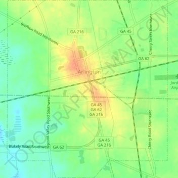
Name: Arlington topographic map, elevation, terrain.
Location: Arlington, Calhoun County, Georgia, United States (31.42070 -84.74233 31.45281 -84.70838)
Average elevation: 77 m
Minimum elevation: 58 m
Maximum elevation: 98 m
Other topographic maps
Click on a map to view its topography, its elevation and its terrain.
Leary
United States > Georgia > Calhoun County
Leary, Calhoun County, Georgia, 39862, United States
Average elevation: 61 m