
Thank you for supporting this site ❤️
Make a donation
Make a donation
Tholen topographic map
Click on the map to display elevation.
Thank you for supporting this site ❤️
Make a donation
Make a donation
About this map
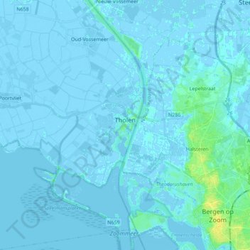
Name: Tholen topographic map, elevation, terrain.
Location: Tholen, Zeeland, Netherlands (51.47956 4.12966 51.58673 4.23629)
Average elevation: 1 m
Minimum elevation: -6 m
Maximum elevation: 17 m
Thank you for supporting this site ❤️
Make a donation
Make a donation
Other topographic maps
Click on a map to view its topography, its elevation and its terrain.