
Imbringen topographic map
Interactive map
Click on the map to display elevation.
About this map
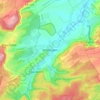
Name: Imbringen topographic map, elevation, terrain.
Location: Imbringen, Junglinster, Canton Grevenmacher, 6195, Luxembourg (49.68002 6.17316 49.72002 6.21316)
Average elevation: 354 m
Minimum elevation: 299 m
Maximum elevation: 438 m
Other topographic maps
Click on a map to view its topography, its elevation and its terrain.
Niederdonven
Luxembourg > Canton Grevenmacher > Niederdonven
Niederdonven, Flaxweiler, Canton Grevenmacher, 5433, Luxembourg
Average elevation: 252 m
Junglinster
Luxembourg > Canton Grevenmacher
Junglinster, Canton Grevenmacher, Luxembourg
Average elevation: 334 m