
Thank you for supporting this site ❤️
Make a donation
Make a donation
Ioannina topographic map
Click on the map to display elevation.
Thank you for supporting this site ❤️
Make a donation
Make a donation
Ioannina
According to the 2021 census, the city population was 64,896 while the municipality had 113,978 inhabitants. It lies at an elevation of approximately 500 metres (1,640 feet) above sea level, on the western shore of Lake Pamvotis (Παμβώτις). Ioannina is located 410 km (255 mi) northwest of Athens, 260 kilometres (162 miles) southwest of Thessaloniki and 80 km (50 miles) east of the port of Igoumenitsa on the Ionian Sea.
Thank you for supporting this site ❤️
Make a donation
Make a donation
About this map
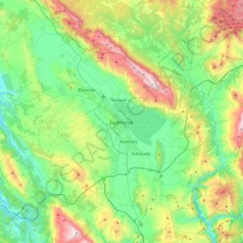
Name: Ioannina topographic map, elevation, terrain.
Average elevation: 724 m
Minimum elevation: 270 m
Maximum elevation: 1,804 m
Thank you for supporting this site ❤️
Make a donation
Make a donation
Other topographic maps
Click on a map to view its topography, its elevation and its terrain.
North Tzoumerka Municipality
Greece > Epirus and Western Macedonia > Ioannina Regional Unit
Average elevation: 990 m