
Hong Kong Island topographic map
Interactive map
Click on the map to display elevation.
About this map
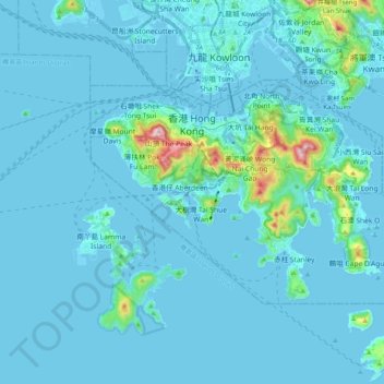
Name: Hong Kong Island topographic map, elevation, terrain.
Location: Hong Kong Island, Hong Kong, China (22.19265 114.10988 22.30028 114.30905)
Average elevation: 36 m
Minimum elevation: -7 m
Maximum elevation: 532 m
Other topographic maps
Click on a map to view its topography, its elevation and its terrain.
Ma Wan
China > Hong Kong > Tsuen Wan District > Sham Tseng Village
Ma Wan, Sham Tseng, Sham Tseng Village, Tsuen Wan District, New Territories, Hong Kong, China
Average elevation: 12 m
Pai Tau Tsuen
China > Hong Kong > Sha Tin > Pai Tau Tsuen
Pai Tau Tsuen, Sha Tin, Sha Tin District, New Territories, Hong Kong, China
Average elevation: 104 m