
Thank you for supporting this site ❤️
Make a donation
Make a donation
Yaroslavl topographic map
Click on the map to display elevation.
Thank you for supporting this site ❤️
Make a donation
Make a donation
About this map
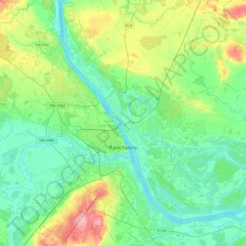
Name: Yaroslavl topographic map, elevation, terrain.
Location: Yaroslavl, Yaroslavl Oblast, Central Federal District, Russia (57.52572 39.72916 57.77528 40.00333)
Average elevation: 108 m
Minimum elevation: 80 m
Maximum elevation: 189 m
Thank you for supporting this site ❤️
Make a donation
Make a donation
Other topographic maps
Click on a map to view its topography, its elevation and its terrain.