
Tufteren topographic map
Interactive map
Click on the map to display elevation.
About this map
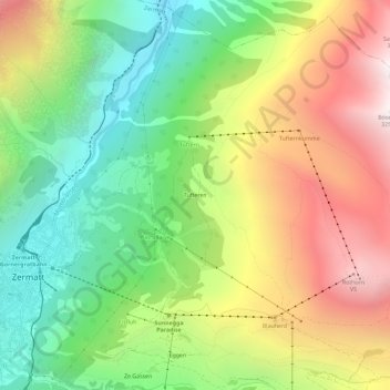
Name: Tufteren topographic map, elevation, terrain.
Location: Tufteren, Zermatt, Viège, Valais, 3920, Suisse (46.00963 7.75395 46.04963 7.79395)
Average elevation: 2,238 m
Minimum elevation: 1,474 m
Maximum elevation: 3,243 m
Other topographic maps
Click on a map to view its topography, its elevation and its terrain.
Schwarzsee
Suisse > Valais > Viège > Zermatt > Schwarzsee
Schwarzsee, Zermatt, Viège, Valais, 3920, Suisse
Average elevation: 2,499 m
Pointe Dufour
Suisse > Valais > Viège > Zermatt
Pointe Dufour, Zermatt, Viège, Valais, 3920, Suisse
Average elevation: 4,033 m
Monte Rosa Hütte
Suisse > Valais > Viège > Zermatt
Monte Rosa Hütte, Panoramaweg, Zermatt, Viège, Valais, 3920, Suisse
Average elevation: 2,892 m