
Col de la Croix Saint-Robert topographic map
Interactive map
Click on the map to display elevation.
About this map
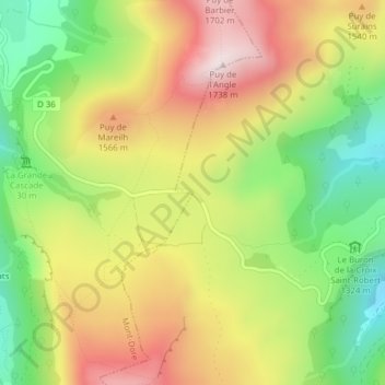
Name: Col de la Croix Saint-Robert topographic map, elevation, terrain.
Average elevation: 1,431 m
Minimum elevation: 1,155 m
Maximum elevation: 1,724 m
Other topographic maps
Click on a map to view its topography, its elevation and its terrain.
Puy de Sancy
France > Auvergne-Rhône-Alpes > Mont-Dore
Puy de Sancy, Itinéraire de Contournement, Mont-Dore, Besse-et-Saint-Anastaise, Puy-de-Dôme, Auvergne-Rhône-Alpes, France métropolitaine, 63240, France
Average elevation: 1,601 m