
Municipal District of Provost topographic map
Interactive map
Click on the map to display elevation.
About this map
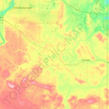
Name: Municipal District of Provost topographic map, elevation, terrain.
Location: Municipal District of Provost, Alberta, T0B 0Z0, Canadá (52.05566 -111.32223 52.73136 -110.00537)
Average elevation: 697 m
Minimum elevation: 581 m
Maximum elevation: 916 m
Other topographic maps
Click on a map to view its topography, its elevation and its terrain.
Kananaskis Improvement District
Kananaskis Improvement District, Alberta, Canadá
Average elevation: 1,740 m
Río Athabasca
Río Athabasca, Municipal District of Lesser Slave River, Alberta, T9S 1H4, Canadá
Average elevation: 696 m