
Cap Blanc-Nez topographic map
Interactive map
Click on the map to display elevation.
About this map
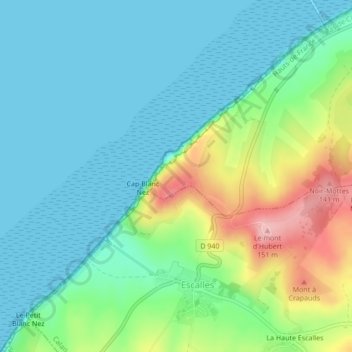
Name: Cap Blanc-Nez topographic map, elevation, terrain.
Average elevation: 39 m
Minimum elevation: 0 m
Maximum elevation: 147 m
Other topographic maps
Click on a map to view its topography, its elevation and its terrain.
Mont d'Hubert
France > Hauts-de-France > Sangatte
Mont d'Hubert, D 940, Sangatte, Calais, Pas-de-Calais, Hauts-de-France, France métropolitaine, 62231, France
Average elevation: 74 m