
Melides topographic map
Interactive map
Click on the map to display elevation.
About this map
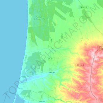
Name: Melides topographic map, elevation, terrain.
Location: Melides, Grândola, Setúbal, Portugal (38.09972 -8.79750 38.25909 -8.64454)
Average elevation: 91 m
Minimum elevation: 0 m
Maximum elevation: 319 m
Other topographic maps
Click on a map to view its topography, its elevation and its terrain.