
Bouillon topographic map
Interactive map
Click on the map to display elevation.
About this map
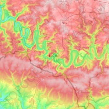
Name: Bouillon topographic map, elevation, terrain.
Location: Bouillon, Neufchâteau, Luxemburg, Wallonië, België (49.70920 4.96844 49.88368 5.18994)
Average elevation: 342 m
Minimum elevation: 168 m
Maximum elevation: 455 m
Other topographic maps
Click on a map to view its topography, its elevation and its terrain.