
Himachal Pradesh topographic map
Interactive map
Click on the map to display elevation.
About this map
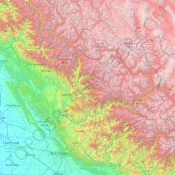
Name: Himachal Pradesh topographic map, elevation, terrain.
Location: Himachal Pradesh, India (30.37717 75.59401 33.25567 79.01238)
Average elevation: 2,869 m
Minimum elevation: 232 m
Maximum elevation: 6,687 m
Due to extreme variation in elevation, great variation occurs in the climatic conditions of Himachal. The climate varies from hot and humid subtropical in the southern tracts to, with more elevation, cold, alpine, and glacial in the northern and eastern mountain ranges. The state's winter capital, Dharamsala receives very heavy rainfall, while areas like Lahaul and Spiti are cold and almost rainless. Broadly, Himachal experiences three seasons: summer, winter, and rainy season. Summer lasts from mid-April till the end of June and most parts become very hot (except in the alpine zone which experiences a mild summer) with the average temperature ranging from 28 to 32 °C (82 to 90 °F). Winter lasts from late November till mid-March. Snowfall is common in alpine tracts. Pollution is affecting the climate of almost all the states of India. Due to steps taken by governments to prevent pollution, Himachal Pradesh has become the first smoke-free state in India which means cooking in the entire state is free of traditional chulhas.
Other topographic maps
Click on a map to view its topography, its elevation and its terrain.
Bengaluru
India > Karnataka > Bangalore North
Bengaluru, Bangalore North, Bengaluru Urban District, Karnataka, India
Average elevation: 881 m
Chennai
India > Tamil Nadu > Chennai
Chennai, Chennai District, Tamil Nadu, India
Average elevation: 8 m
Gangodanahalli
India > Karnataka > Bangalore North
Gangodanahalli, Bangalore North, Bengaluru Urban, Karnataka, 560018, India
Average elevation: 865 m
3d
India > Rajasthan > Ganganagar Tehsil > 1 LNP
3d, 1 LNP, Ganganagar Tehsil, Sri Ganganagar District, Rajasthan, India
Average elevation: 178 m
Kachohalli
India > Karnataka > Bangalore North
Kachohalli, Bangalore North, Bengaluru Urban, Karnataka, 560018, India
Average elevation: 868 m
Shimla
India > Himachal Pradesh > Shimla (urban)
Shimla, Shimla (urban), Shimla District, Himachal Pradesh, 171001, India
Average elevation: 1,557 m
Sheoganj
India > Rajasthan > Sheoganj Tehsil
Sheoganj, Sheoganj Tehsil, Sirohi District, Rajasthan, 306902, India
Average elevation: 271 m
Kodaikanal
Kodaikanal, Dindigul District, Tamil Nadu, India
Average elevation: 869 m
Bhatrahalli
India > Karnataka > Kolar taluk
Bhatrahalli, Kolar taluk, Kolar District, Karnataka, India
Average elevation: 825 m
Kambalipura
India > Karnataka > Anekal > Kambalipura
Kambalipura, Anekal, Bengaluru Urban, Karnataka, India
Average elevation: 886 m
Whitefield
India > Karnataka > Bangalore East > Bengaluru
Whitefield, Bengaluru, Bangalore East, Bengaluru Urban District, Karnataka, 560066, India
Average elevation: 875 m
Hosur
India > Tamil Nadu > Hosur
Hosur, Krishnagiri District, Tamil Nadu, 635109, India
Average elevation: 859 m
Karaikudi
India > Tamil Nadu > Karaikkudi
Karaikudi, Karaikkudi, Sivagangai District, Tamil Nadu, 623001, India
Average elevation: 87 m
Bachupally mandal
Bachupally mandal, Medchal–Malkajgiri District, Telangana, 500090, India
Average elevation: 593 m
Coimbatore
India > Tamil Nadu > Coimbatore North
Coimbatore, Coimbatore North, Coimbatore District, Tamil Nadu, 641001, India
Average elevation: 452 m
Pune
India > Maharashtra > Pune City > Pune
Pune, Pune City, Pune District, Maharashtra, 411001, India
Average elevation: 641 m
Kolkata
Kolkata, Kolkata District, West Bengal, 700073, India
Average elevation: 5 m
North Sentinel Island
India > Andaman and Nicobar Islands > Ferrargunj
North Sentinel Island, Ferrargunj, South Andaman District, Andaman and Nicobar Islands, India
Average elevation: 20 m
Gurgaon
India > Haryana > Gurugram District
Gurgaon, Gurugram District, Haryana, India
Average elevation: 237 m
Western Ghats
Western Ghats, Idukki, Kerala, 685614, India
Average elevation: 2,225 m
Srinagar
India > Jammu and Kashmir > Srinagar (South)
Srinagar, Srinagar (South), Srinagar District, Jammu and Kashmir, 190001, India
Average elevation: 1,805 m
Prayagraj
India > Uttar Pradesh > Prayagraj
Prayagraj, Prayagraj District, Uttar Pradesh, 211001, India
Average elevation: 91 m
Kodia God
India > Madhya Pradesh > Narsinghgarh Tahsil
Kodia God, Narsinghgarh Tahsil, Rajgarh District, Madhya Pradesh, India
Average elevation: 430 m
riyuni tal
India > Uttarakhand > Ranikhet > Majkhali
riyuni tal, Majkhali, Ranikhet, Almora District, Uttarakhand, 263652, India
Average elevation: 1,567 m
Varana
India > Gujarat > Sami Taluka
Varana, Sami Taluka, Patan District, Gujarat, India
Average elevation: 32 m
Vagamon Lake
India > Kerala > Peerumade > Vagamon
Vagamon Lake, Vagamon, Peerumade, Idukki District, Kerala, India
Average elevation: 976 m