
Frauenfeld topographic map
Interactive map
Click on the map to display elevation.
About this map
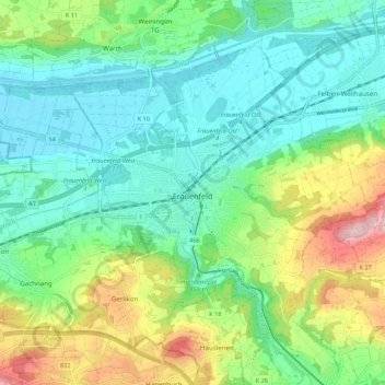
Name: Frauenfeld topographic map, elevation, terrain.
Location: Frauenfeld, Bezirk Frauenfeld, Thurgovie, Suisse (47.52703 8.83774 47.58656 8.94582)
Average elevation: 459 m
Minimum elevation: 379 m
Maximum elevation: 652 m
Other topographic maps
Click on a map to view its topography, its elevation and its terrain.
Gerlikon
Suisse > Thurgovie > Bezirk Frauenfeld > Frauenfeld
Gerlikon, Frauenfeld, Neunforn, Bezirk Frauenfeld, Thurgovie, 8500, Suisse
Average elevation: 495 m
Steckborn
Suisse > Thurgovie > Bezirk Frauenfeld
Steckborn, Bezirk Frauenfeld, Thurgovie, 8266, Suisse
Average elevation: 511 m