
Oxford topographic map
Interactive map
Click on the map to display elevation.
About this map
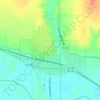
Name: Oxford topographic map, elevation, terrain.
Location: Oxford, Furnas County, Nebraska, 68967, United States (40.24298 -99.64445 40.26360 -99.62100)
Average elevation: 643 m
Minimum elevation: 623 m
Maximum elevation: 677 m
Other topographic maps
Click on a map to view its topography, its elevation and its terrain.
Cambridge
United States > Nebraska > Furnas County
Cambridge, Furnas County, Nebraska, 69022, United States
Average elevation: 699 m
Arapahoe
United States > Nebraska > Furnas County
Arapahoe, Furnas County, Nebraska, 68922, United States
Average elevation: 666 m