
Make a donation
Lacenas topographic map
Click on the map to display elevation.
Make a donation
Lacenas
Lacenas est un village situé à 6 km de Villefranche-sur-Saône. Il se situe à 290 mètres d’altitude avec une altitude minimum de 229 m et maximum de 371 m. Géographiquement la latitude de Lacenas est de 45.992 degrés Nord et sa longitude de 4.646 degrés Est. La superficie de Lacenas est de 3.36 km² soit 336 hectares ; Les communes limitrophes de Lacenas sont Denicé qui se situe à 1.35 km au nord, Cogny qui se situe à 1.69 km à l’ouest, Liergue se situe à 2.93 km au sud et enfin Gleizé à l’est se situe à 4.13 km.
Make a donation
About this map
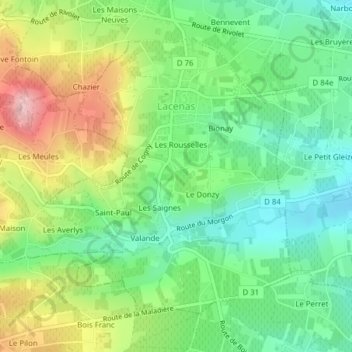
Name: Lacenas topographic map, elevation, terrain.
Average elevation: 296 m
Minimum elevation: 226 m
Maximum elevation: 411 m
Make a donation
Other topographic maps
Click on a map to view its topography, its elevation and its terrain.
Signal de Saint-André
France > Auvergne-Rhône-Alpes > Rhône > Saint-André-la-Côte
Le signal de Saint-André est un sommet situé sur la commune de Saint-André-la-Côte dans le département français du Rhône, sur la ligne de crêtes principale des monts du Lyonnais. Avec 934 mètres d'altitude, il est seulement dépassé par le crêt Malherbe. Il est situé à 20 kilomètres à l'ouest de Lyon.
Average elevation: 780 m
Make a donation
Château de Pizay
France > Auvergne-Rhône-Alpes > Rhône > Belleville-en-Beaujolais > Saint-Jean-d'Ardières > Pizay
Average elevation: 223 m
Make a donation
La Maletière
France > Auvergne-Rhône-Alpes > Rhône > Saint-Clément-sur-Valsonne
Average elevation: 475 m
Make a donation
Make a donation
Make a donation
Les Arnauds du Haut
France > Auvergne-Rhône-Alpes > Rhône > Lamure-sur-Azergues
Average elevation: 490 m
Les Coasses
France > Auvergne-Rhône-Alpes > Rhône > Val d'Oingt > Le Bois-d'Oingt
Average elevation: 354 m
Make a donation
Col du Chêne
France > Auvergne-Rhône-Alpes > Rhône > Sainte-Paule > Le Châtoux
Average elevation: 623 m
Make a donation
Le Mincieux
France > Auvergne-Rhône-Alpes > Rhône > Beauvallon > Saint-Jean-de-Touslas
Average elevation: 296 m
Make a donation
Make a donation
La Grosne Orientale
France > Auvergne-Rhône-Alpes > Rhône > Deux-Grosnes > Ouroux
Average elevation: 568 m
Make a donation
Bois de la Salle
France > Auvergne-Rhône-Alpes > Rhône > Juliénas > Bois de la Salle
Average elevation: 338 m
Make a donation
Sainte-Catherine
France > Auvergne-Rhône-Alpes > Rhône > Sainte-Catherine > Sainte-Catherine
Sainte Catherine est une commune française située à 680 m d’altitude dans le département du Rhône, en région Auvergne-Rhone-Alpes.
Average elevation: 723 m
Lamure-sur-Azergues
France > Auvergne-Rhône-Alpes > Rhône > Lamure-sur-Azergues > Lamure-sur-Azergues
Situé à une cinquantaine de kilomètres au nord-ouest de l'agglomération lyonnaise, le village de Lamure-sur-Azergues est en plein cœur du Beaujolais vert. Un territoire où se marient espaces boisés et agricoles pour former des paysages bien agréables à l'œil. Le village de Lamure est niché au cœur…
Average elevation: 526 m
Saint-Romain-en-Gal
France > Auvergne-Rhône-Alpes > Rhône > Saint-Romain-en-Gal > Saint-Romain-en-Gal
Average elevation: 230 m
Make a donation
Saint-Pierre-la-Palud
France > Auvergne-Rhône-Alpes > Rhône > Saint-Pierre-la-Palud > Saint-Pierre-la-Palud
Average elevation: 413 m
Make a donation
Plan d'Eau de Bordelan
France > Auvergne-Rhône-Alpes > Rhône > Villefranche-sur-Saône
Average elevation: 186 m
Make a donation
La Savoie
France > Auvergne-Rhône-Alpes > Rhône > Vindry-sur-Turdine > Pontcharra-sur-Turdine
Average elevation: 392 m
Make a donation
Make a donation
Guillaume
France > Auvergne-Rhône-Alpes > Rhône > Saint-Laurent-de-Vaux > Le Cholly
Average elevation: 568 m
Make a donation
Make a donation
Le Colin
France > Auvergne-Rhône-Alpes > Rhône > Thizy-les-Bourgs > Bourg-de-Thizy
Average elevation: 445 m
Make a donation
La Croix Saint-Jean
France > Auvergne-Rhône-Alpes > Rhône > Thizy-les-Bourgs > Mardore > La Montagne
Average elevation: 606 m
Make a donation
La Terrasse de Chiroubles
France > Auvergne-Rhône-Alpes > Rhône > Chiroubles > Les Saignes
Average elevation: 634 m
Make a donation
Make a donation
Les Charbonniers
France > Auvergne-Rhône-Alpes > Rhône > Deux-Grosnes > Monsols
Average elevation: 646 m
Make a donation
Make a donation
Château de Montlys
France > Auvergne-Rhône-Alpes > Rhône > Saint-Cyr-sur-le-Rhône > Le Mont
Average elevation: 225 m
Make a donation