
Thank you for supporting this site ❤️
Make a donation
Make a donation
Kırıntı topographic map
Click on the map to display elevation.
Thank you for supporting this site ❤️
Make a donation
Make a donation
About this map
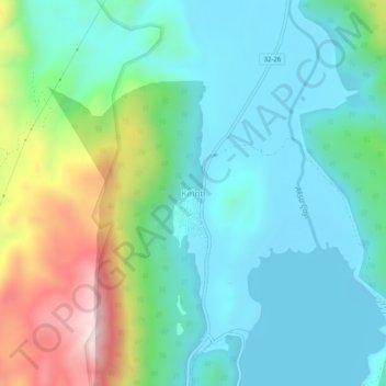
Name: Kırıntı topographic map, elevation, terrain.
Location: Kırıntı, Eğirdir, Isparta, Mediterranean Region, Turkey (37.64276 30.84359 37.68276 30.88359)
Average elevation: 1,076 m
Minimum elevation: 900 m
Maximum elevation: 1,595 m
Thank you for supporting this site ❤️
Make a donation
Make a donation