
Thank you for supporting this site ❤️
Make a donation
Make a donation
Loeriesfontein topographic map
Click on the map to display elevation.
Thank you for supporting this site ❤️
Make a donation
Make a donation
About this map
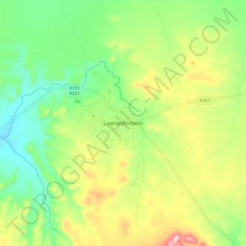
Name: Loeriesfontein topographic map, elevation, terrain.
Average elevation: 903 m
Minimum elevation: 790 m
Maximum elevation: 1,082 m
Thank you for supporting this site ❤️
Make a donation
Make a donation
Other topographic maps
Click on a map to view its topography, its elevation and its terrain.
Hantam National Botanical Garden
South Africa > Northern Cape > Namakwa District Municipality > Hantam Local Municipality
Average elevation: 698 m