
Beauregard topographic map
Interactive map
Click on the map to display elevation.
About this map
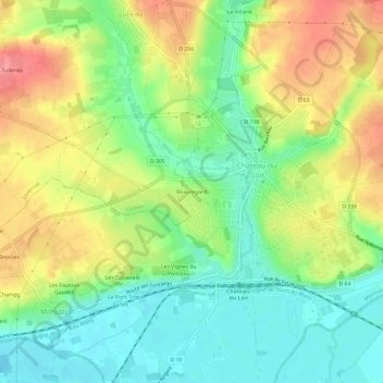
Name: Beauregard topographic map, elevation, terrain.
Average elevation: 76 m
Minimum elevation: 40 m
Maximum elevation: 124 m
Other topographic maps
Click on a map to view its topography, its elevation and its terrain.
Vouvray-sur-Loir
France > Pays de la Loire > Sarthe > Montval-sur-Loir
Vouvray-sur-Loir, Montval-sur-Loir, La Flèche, Sarthe, Pays de la Loire, France métropolitaine, 72500, France
Average elevation: 74 m
Château-du-Loir
France > Pays de la Loire > Sarthe > Montval-sur-Loir
Château-du-Loir, Montval-sur-Loir, La Flèche, Sarthe, Pays de la Loire, France métropolitaine, 72500, France
Average elevation: 82 m