
Triangle topographic map
Click on the map to display elevation.
About this map
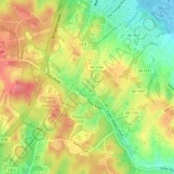
Name: Triangle topographic map, elevation, terrain.
Average elevation: 43 m
Minimum elevation: -7 m
Maximum elevation: 82 m
Other topographic maps
Click on a map to view its topography, its elevation and its terrain.
Occoquan Bay National Wildlife Refuge
United States > Virginia > Prince William County > Woodbridge
Average elevation: 3 m
Chamberlain Village
United States > Virginia > Prince William County > Quantico > Chamberlain Village
Average elevation: 16 m
Bull Run Mountain Estates
United States > Virginia > Prince William County > Bull Run Mountain Estates
Average elevation: 197 m
Silver Lake Regional Park
United States > Virginia > Prince William County > Haymarket
Average elevation: 131 m