
Thank you for supporting this site ❤️
Make a donation
Make a donation
Hochatown topographic map
Click on the map to display elevation.
Thank you for supporting this site ❤️
Make a donation
Make a donation
About this map
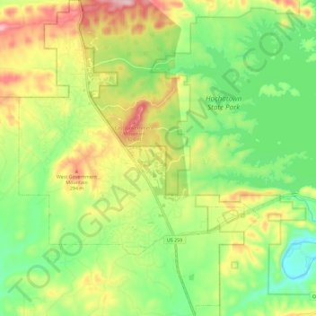
Name: Hochatown topographic map, elevation, terrain.
Location: Hochatown, McCurtain County, Oklahoma, United States (34.12113 -94.80258 34.21456 -94.71623)
Average elevation: 218 m
Minimum elevation: 127 m
Maximum elevation: 346 m
Thank you for supporting this site ❤️
Make a donation
Make a donation
Other topographic maps
Click on a map to view its topography, its elevation and its terrain.