
Make a donation
Scarborough topographic map
Click on the map to display elevation.
Make a donation
Scarborough
The climate is temperate with mild summers and cool, windy, winters. The hottest months of the year are July and August, with temperatures reaching an average high of 17 °C and falling to 11 °C at night. The average daytime temperatures in January are 4 °C, falling to 1 °C at night. The station's elevation of 110 m (360 ft) is far above sea level compared to the immediate coastline, where the climate is likely slightly milder year round.
Make a donation
About this map
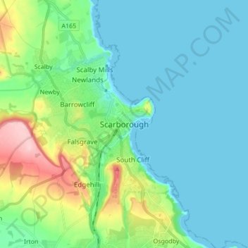
Name: Scarborough topographic map, elevation, terrain.
Average elevation: 39 m
Minimum elevation: -1 m
Maximum elevation: 184 m
Make a donation
Other topographic maps
Click on a map to view its topography, its elevation and its terrain.
Scarborough
United Kingdom > England > North Yorkshire > Scarborough
The climate is temperate with mild summers and cool, windy, winters. The hottest months of the year are July and August, with temperatures reaching an average high of 17 °C and falling to 11 °C at night. The average daytime temperatures in January are 4 °C, falling to 1 °C at night. The station's elevation…
Average elevation: 50 m
Craven
United Kingdom > England > North Yorkshire
Vegetation in the Pennines is adapted to subarctic climates, but altitude and acidity are also factors. For example, on Sutton Moor the millstone grit's topsoil below 275 m (902 ft) has a soil ph that is almost neutral, ph 6 to 7, and so grows good grazing. However, above 275 m (902 ft) it is acidic, ph 2 to…
Average elevation: 294 m