
Thank you for supporting this site ❤️
Make a donation
Make a donation
Nquthu topographic map
Click on the map to display elevation.
Thank you for supporting this site ❤️
Make a donation
Make a donation
About this map
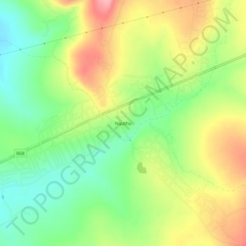
Name: Nquthu topographic map, elevation, terrain.
Average elevation: 1,175 m
Minimum elevation: 1,119 m
Maximum elevation: 1,243 m
Thank you for supporting this site ❤️
Make a donation
Make a donation
Other topographic maps
Click on a map to view its topography, its elevation and its terrain.
Nondweni
South Africa > KwaZulu-Natal > Umzinyathi District Municipality > Nquthu Local Municipality
Average elevation: 995 m
Nquthu Ward 17
South Africa > KwaZulu-Natal > Umzinyathi District Municipality > Nquthu Local Municipality
Average elevation: 1,240 m