
Thank you for supporting this site ❤️
Make a donation
Make a donation
Bodie topographic map
Click on the map to display elevation.
Thank you for supporting this site ❤️
Make a donation
Make a donation
Bodie
Bodie (/ˈboʊdiː/ BOH-dee) is a ghost town in the Bodie Hills east of the Sierra Nevada mountain range in Mono County, California, United States. It is about 75 miles (121 km) southeast of Lake Tahoe, and 12 mi (19 km) east-southeast of Bridgeport, at an elevation of 8,379 feet (2554 m). Bodie became a boom town in 1876 (147 years ago) (1876) after the discovery of a profitable line of gold; by 1879 it had a population of 7,000–10,000.
Thank you for supporting this site ❤️
Make a donation
Make a donation
About this map
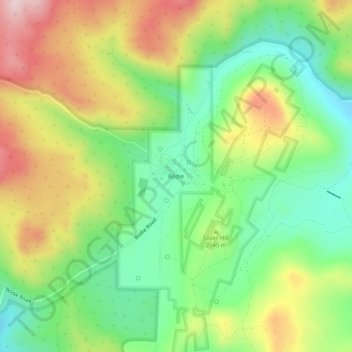
Name: Bodie topographic map, elevation, terrain.
Location: Bodie, Mono County, California, United States (38.19149 -119.03259 38.23149 -118.99259)
Average elevation: 2,627 m
Minimum elevation: 2,487 m
Maximum elevation: 2,821 m
Thank you for supporting this site ❤️
Make a donation
Make a donation