
Make a donation
Gila Bend topographic map
Click on the map to display elevation.
Make a donation
Gila Bend
According to the United States Census Bureau, the town has a total area of 64.4 square miles (167 km2), all of it land. Situated at 735 feet (224 m) above sea level, Gila Bend has the lowest elevation of any city in Maricopa County and in Greater Phoenix overall.
Make a donation
About this map
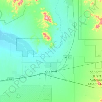
Name: Gila Bend topographic map, elevation, terrain.
Location: Gila Bend, Maricopa County, Arizona, United States (32.88360 -112.90845 33.11638 -112.59875)
Average elevation: 257 m
Minimum elevation: 180 m
Maximum elevation: 684 m
Make a donation
Other topographic maps
Click on a map to view its topography, its elevation and its terrain.
Salt River
United States > Arizona > Maricopa County
Salt River is a populated place situated in Maricopa County, Arizona, United States. It has an estimated elevation of 1,220 feet (370 m) above sea level. It is located on the Salt River Pima–Maricopa Indian Community.
Average elevation: 372 m