
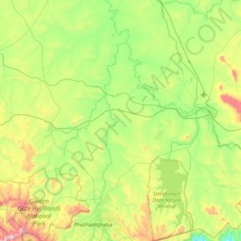
Maluti-a-Phofung Ward 6 topographic map
Interactive map
Click on the map to display elevation.
About this map
Name: Maluti-a-Phofung Ward 6 topographic map, elevation, terrain.
Average elevation: 1,729 m
Minimum elevation: 1,303 m
Maximum elevation: 2,795 m
Other topographic maps
Click on a map to view its topography, its elevation and its terrain.
Phuthaditjhaba
South Africa > Free State > Thabo Mofutsanyana District Municipality > Maluti-a-Phofung Local Municipality
Phuthaditjhaba, Maluti-a-Phofung Local Municipality, Thabo Mofutsanyana District Municipality, Free State, 9866, South Africa
Average elevation: 1,736 m
Rainfall Dam
South Africa > Free State > Thabo Mofutsanyana District Municipality > Maluti-a-Phofung Local Municipality
Rainfall Dam, Maluti-a-Phofung Ward 22, Maluti-a-Phofung Local Municipality, Thabo Mofutsanyana District Municipality, Free State, South Africa
Average elevation: 1,707 m
iNtabazwe (Harrismith)
South Africa > Free State > Thabo Mofutsanyana District Municipality > Maluti-a-Phofung Local Municipality
iNtabazwe (Harrismith), Maluti-a-Phofung Local Municipality, Thabo Mofutsanyana District Municipality, Free State, 9880, South Africa
Average elevation: 1,716 m
Sterkfontein Dam
South Africa > Free State > Thabo Mofutsanyana District Municipality > Maluti-a-Phofung Local Municipality
Sterkfontein Dam, Maluti-a-Phofung Ward 6, Maluti-a-Phofung Local Municipality, Thabo Mofutsanyana District Municipality, Free State, South Africa
Average elevation: 1,677 m
Maluti-a-Phofung Ward 11
South Africa > Free State > Thabo Mofutsanyana District Municipality > Maluti-a-Phofung Local Municipality
Maluti-a-Phofung Ward 11, Maluti-a-Phofung Local Municipality, Thabo Mofutsanyana District Municipality, Free State, South Africa
Average elevation: 2,050 m