
Kanawha County topographic map
Interactive map
Click on the map to display elevation.
About this map
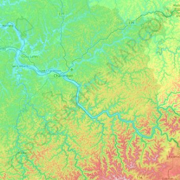
Name: Kanawha County topographic map, elevation, terrain.
Location: Kanawha County, West Virginia, United States (37.96721 -81.91584 38.62730 -81.19455)
Average elevation: 346 m
Minimum elevation: 170 m
Maximum elevation: 869 m
Other topographic maps
Click on a map to view its topography, its elevation and its terrain.
The Orchard
United States > West Virginia > Brooke County > Follansbee
The Orchard, Follansbee, Follansbee District, Brooke County, West Virginia, 26037, United States
Average elevation: 269 m
Craddock
United States > West Virginia > Upshur County
Craddock, Upshur County, West Virginia, 26236, United States
Average elevation: 737 m
Raven Rocks
United States > West Virginia > Hampshire County
Raven Rocks, Hampshire County, West Virginia, United States
Average elevation: 314 m
Location
United States > West Virginia > Location
Location, Tucker County, West Virginia, United States
Average elevation: 722 m