
Anivorano topographic map
Interactive map
Click on the map to display elevation.
About this map
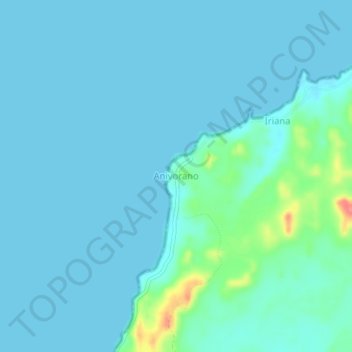
Name: Anivorano topographic map, elevation, terrain.
Average elevation: 9 m
Minimum elevation: 0 m
Maximum elevation: 71 m
Other topographic maps
Click on a map to view its topography, its elevation and its terrain.
Île Sainte-Marie
Madagascar > Analanjirofo > District de Nosy Boraha
Île Sainte-Marie, District de Nosy Boraha, Analanjirofo, Province de Tamatave, Madagascar
Average elevation: 3 m
District de Nosy Boraha
Madagascar > Analanjirofo > District de Nosy Boraha
District de Nosy Boraha, Analanjirofo, Province de Tamatave, Madagascar
Average elevation: 2 m