
Bila Tserkva topographic map
Interactive map
Click on the map to display elevation.
About this map
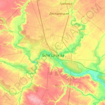
Name: Bila Tserkva topographic map, elevation, terrain.
Location: Bila Tserkva, Kyiv Oblast, 09100-09117, Ukraine (49.64382 29.95169 49.96382 30.27169)
Average elevation: 181 m
Minimum elevation: 135 m
Maximum elevation: 231 m
Other topographic maps
Click on a map to view its topography, its elevation and its terrain.
The Cliff Pond
Ukraine > Kyiv Oblast > Bila Tserkva
The Cliff Pond, Spruce Avenue, Піонерська, Bila Tserkva, Kyiv Oblast, 09100-09117, Ukraine
Average elevation: 165 m