
Ville-Marie topographic map
Interactive map
Click on the map to display elevation.
About this map
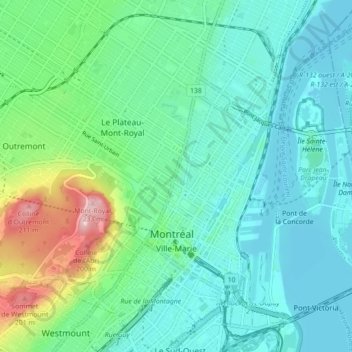
Name: Ville-Marie topographic map, elevation, terrain.
Average elevation: 30 m
Minimum elevation: 3 m
Maximum elevation: 229 m
Other topographic maps
Click on a map to view its topography, its elevation and its terrain.
Isla de Montreal
Isla de Montreal, Montreal, Agglomération de Montréal, Montréal (06), Quebec, Canadá
Average elevation: 30 m