
Berdorf topographic map
Interactive map
Click on the map to display elevation.
About this map
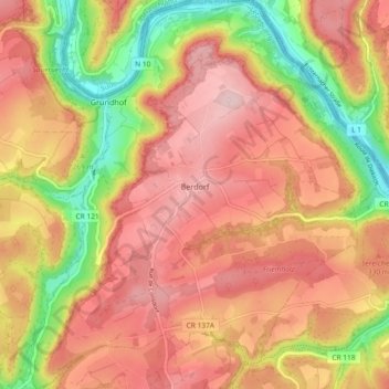
Name: Berdorf topographic map, elevation, terrain.
Location: Berdorf, Canton Echternach, Luxembourg (49.79136 6.31131 49.85077 6.38952)
Average elevation: 300 m
Minimum elevation: 159 m
Maximum elevation: 396 m
Other topographic maps
Click on a map to view its topography, its elevation and its terrain.
Beaufort
Luxembourg > Canton Echternach
Beaufort, Canton Echternach, Luxembourg
Average elevation: 326 m
Mullerthal
Luxembourg > Canton Echternach > Waldbillig
Mullerthal, Waldbillig, Canton Echternach, 6245, Luxembourg
Average elevation: 313 m
Echternach
Luxembourg > Canton Echternach
Echternach, Canton Echternach, Luxembourg
Average elevation: 284 m