
Hauterive topographic map
Interactive map
Click on the map to display elevation.
About this map
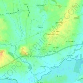
Name: Hauterive topographic map, elevation, terrain.
Average elevation: 145 m
Minimum elevation: 133 m
Maximum elevation: 165 m
Other topographic maps
Click on a map to view its topography, its elevation and its terrain.
Carrefour des Quatre Arpents
France > Normandie > Orne > Saint-Nicolas-des-Bois
Average elevation: 350 m
Le Gros Chene
France > Normandie > Orne > Rives-d'Andaine > La Chapelle-d'Andaine
Average elevation: 201 m
Les Hauts de Saint-Mard
France > Normandie > Orne > Sainte-Céronne-lès-Mortagne
Average elevation: 205 m
Lac de Rabodanges
France > Normandie > Orne > Putanges-le-Lac > Sainte-Croix-sur-Orne
Average elevation: 176 m
Le Moulin à Vent
France > Normandie > Orne > Mortagne-au-Perche > Saint Germain-De-Loisé
Average elevation: 220 m
Les Martellières
France > Normandie > Orne > Juvigny-Val-d'Andaine > Sept-Forges
Average elevation: 125 m
La Bunodière
France > Normandie > Orne > Athis-Val-de-Rouvre > Athis-de-l'Orne
Average elevation: 218 m
Moulicent
France > Normandie > Orne > Longny les Villages
Moulicent est un village de l'Orne dans la région de Basse-Normandie qui fait partie du canton de Longny-au-Perche. Située dans le Perche entre 170 et 246 mètres d'altitude et voisine des communes de Longny-au-Perche et de Marchainville, sa superficie est de 33,41 km².
Average elevation: 219 m
Le Cauche de la Sapaie
France > Normandie > Orne > Saint-Symphorien-des-Bruyères
Average elevation: 258 m
Les Milles Mottes
France > Normandie > Orne > Bagnoles-de-l'Orne-Normandie > Bagnoles-de-l'Orne
Average elevation: 191 m