
Thank you for supporting this site ❤️
Make a donation
Make a donation
Weld topographic map
Click on the map to display elevation.
Thank you for supporting this site ❤️
Make a donation
Make a donation
About this map
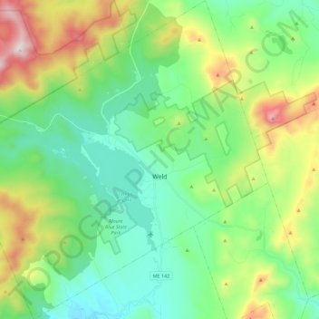
Name: Weld topographic map, elevation, terrain.
Location: Weld, Franklin County, Maine, 04285, United States (44.62723 -70.56380 44.78701 -70.34519)
Average elevation: 408 m
Minimum elevation: 134 m
Maximum elevation: 1,073 m
Thank you for supporting this site ❤️
Make a donation
Make a donation
Other topographic maps
Click on a map to view its topography, its elevation and its terrain.