
San Carlos de Bariloche topographic map
Interactive map
Click on the map to display elevation.
About this map
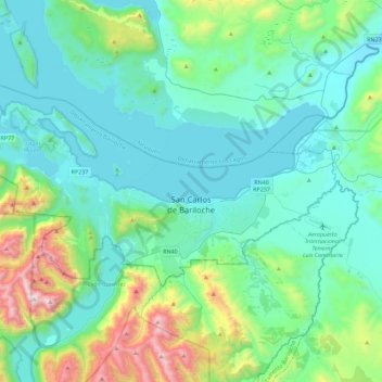
Name: San Carlos de Bariloche topographic map, elevation, terrain.
Average elevation: 1,042 m
Minimum elevation: 756 m
Maximum elevation: 2,348 m
Bariloche lies in the transition between a cool Mediterranean climate (Köppen Csb) and an Oceanic climate (Köppen: Cfb), with marked alpine characteristics (low nighttime temperatures, wide temperature variations, high thermal amplitude). The combination of its altitude, latitude, and predominance of west-northwest winds cause the climate to be classified as a cool temperate climate with a dry season that presents a west–east precipitation gradient. Mean annual precipitation ranges from 4,000 mm (157 in) in the Andean peaks and in Puerto Blest to only 600 mm (24 in) in the Limay River area. In the urban areas, mean annual precipitation ranges from 800 to 1,000 mm (31 to 39 in). Most of this is concentrated in autumn and winter, which are responsible for 70% of the annual precipitation.