
Fontanelle topographic map
Interactive map
Click on the map to display elevation.
About this map
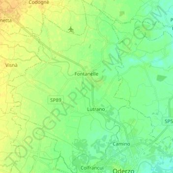
Name: Fontanelle topographic map, elevation, terrain.
Location: Fontanelle, Treviso, Vénétie, 31043, Italie (45.78239 12.41184 45.86762 12.49885)
Average elevation: 16 m
Minimum elevation: 5 m
Maximum elevation: 29 m
Other topographic maps
Click on a map to view its topography, its elevation and its terrain.
Zero Branco
Zero Branco, Treviso, Vénétie, 31059, Italie
Average elevation: 14 m