
Thank you for supporting this site ❤️
Make a donation
Make a donation
Kanonkop topographic map
Click on the map to display elevation.
Thank you for supporting this site ❤️
Make a donation
Make a donation
About this map
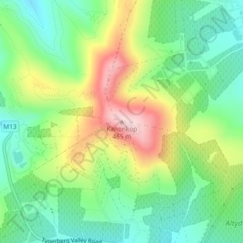
Name: Kanonkop topographic map, elevation, terrain.
Average elevation: 276 m
Minimum elevation: 165 m
Maximum elevation: 461 m
Thank you for supporting this site ❤️
Make a donation
Make a donation
Other topographic maps
Click on a map to view its topography, its elevation and its terrain.
Cape Town Ward 21
South Africa > Western Cape > City of Cape Town > Bellville
Average elevation: 132 m