
南都留郡 topographic map
Interactive map
Click on the map to display elevation.
About this map
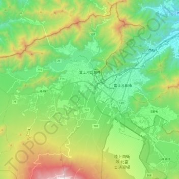
Name: 南都留郡 topographic map, elevation, terrain.
Location: 富士河口湖町, 南都留郡, Prefectura de Yamanashi, 中部地方, Japón (35.39316 138.58186 35.57226 138.81045)
Average elevation: 1,127 m
Minimum elevation: 523 m
Maximum elevation: 2,467 m
Other topographic maps
Click on a map to view its topography, its elevation and its terrain.
Monte Fuji
Japón > 中部地方 > Fujinomiya
Monte Fuji, Fujinomiya, Distrito de Sunto, Prefectura de Shizuoka, 中部地方, Japón
Average elevation: 3,261 m