
Kohima topographic map
Interactive map
Click on the map to display elevation.
About this map
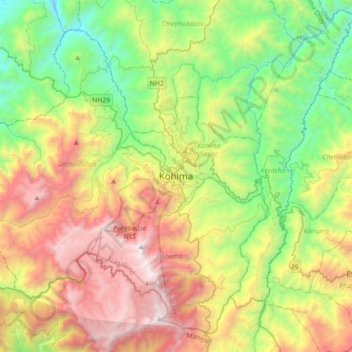
Name: Kohima topographic map, elevation, terrain.
Location: Kohima, Kohima Sadar, Kohima, Nagaland, 797001, India (25.50188 93.94192 25.82188 94.26192)
Average elevation: 1,425 m
Minimum elevation: 430 m
Maximum elevation: 2,993 m
Kohima district is the land of the Angami Naga and Rengma Naga tribe. It is situated in the foothills of Japfu range located south of Kohima District (25°40′N 94°07′E / 25.67°N 94.12°E / 25.67; 94.12) and has an average elevation of 1,261 metres (4137 feet).