
Thank you for supporting this site ❤️
Make a donation
Make a donation
Mount Carleton topographic map
Click on the map to display elevation.
Thank you for supporting this site ❤️
Make a donation
Make a donation
About this map
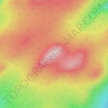
Name: Mount Carleton topographic map, elevation, terrain.
Average elevation: 657 m
Minimum elevation: 436 m
Maximum elevation: 795 m
Thank you for supporting this site ❤️
Make a donation
Make a donation
Other topographic maps
Click on a map to view its topography, its elevation and its terrain.
Trout Brook
Canada > New Brunswick > Greater Miramichi Rural District > Northesk Parish
Average elevation: 99 m