Geolocate
👉 Easily get elevation data in JSON, GeoTIFF and KML formats using Elevation API
Thank you for supporting this site ❤️
Make a donation

De Rust topographic map

Click on the map to display elevation.

👉 Easily get elevation data in JSON, GeoTIFF and KML formats using Elevation API
Thank you for supporting this site ❤️
Make a donation

About this map

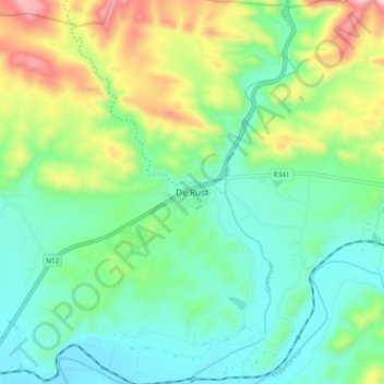
Name: De Rust topographic map, elevation, terrain.

Location: De Rust, George, Western Cape, 6651, South Africa (-33.52959 22.49527 -33.44959 22.57527)

Average elevation: 544 m

Minimum elevation: 381 m

Maximum elevation: 936 m

Other topographic maps

Click on a map to view its topography, its elevation and its terrain.

Touwsranten

South Africa > Western Cape > George

Average elevation: 202 m

Danabaai

South Africa > Western Cape > George

Average elevation: 109 m

Oudtshoorn

South Africa > Western Cape > George

Average elevation: 353 m

Oudtshoorn

South Africa > Western Cape > George

Average elevation: 353 m

Friemersheim

South Africa > Western Cape > George

Average elevation: 262 m

Oudtshoorn

South Africa > Western Cape > George

Average elevation: 353 m

Garden Route Dam

South Africa > Western Cape > George

Average elevation: 200 m